

Navigation apps are now part of daily life, guiding drivers, delivery fleets, and travelers across cities and highways. But when internet connections drop, these systems often fail, leaving users without reliable directions.
Patent US9549388B2 tackles this problem with a hybrid approach. It combines locally stored offline maps with real-time data from wireless networks, ensuring navigation continues even without connectivity. Moreover, by factoring in traffic conditions, the system makes routing smarter and more efficient.
The patent is currently tied to litigation between the assignee, Traxcell Technologies II, LLC, and Maplebear, Inc., yet the bigger story is its role in shaping modern navigation.
In this article, we will unpack how US9549388B2 works and use the Global Patent Search tool to explore similar patents that show how navigation systems have evolved to balance offline reliability with online intelligence.
Understanding Patent US9549388B2
Simply put, US9549388B2 introduces a mobile wireless device designed to provide both offline and online navigation. The invention solves a key challenge in modern travel: ensuring continuous guidance even when connectivity is limited. It does so by combining locally stored maps with network-based data, allowing navigation to function seamlessly in both connected and disconnected environments.
The result is a system that not only keeps directions available at all times but also improves the quality of routing. By incorporating traffic congestion data from the wireless network, the device can generate faster and more efficient routes. This makes it particularly useful in urban environments where delays are common and traditional GPS systems often fall short.
Source: Google Patents
The Key Features Of This Patent Are:
1. Dual navigation capability: The device offers both offline access to stored maps and online updates from the network.
2. Traffic-aware routing: Routes are optimized using congestion data collected by the wireless network.
3. Dynamic map updates: When stored data is insufficient, the system requests additional mapping information.
4. User-controlled privacy: Preference flags allow users to permit or block location tracking by the network.
The patent also includes several additional features that strengthen its value. Routes can be divided into segments, each with calculated travel times, which improves accuracy in estimating arrivals. Importantly, location determination can take place either within the mobile device or through the wireless network, adding flexibility to its implementation.
For a deeper look at how carriers manage congestion for real-time services, see EP3107243B1 and similar patents that make wireless networks handle congestion better.
Similar Patents To US9549388B2
To explore the navigation technology behind US9549388B2, we used the Global Patent Search tool to identify related inventions. These references focus on wireless geographic positioning, mobile location tracking, and integration of network intelligence into navigation systems. Each addresses different aspects of how wireless devices provide accurate, real-time location data.
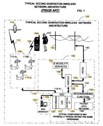
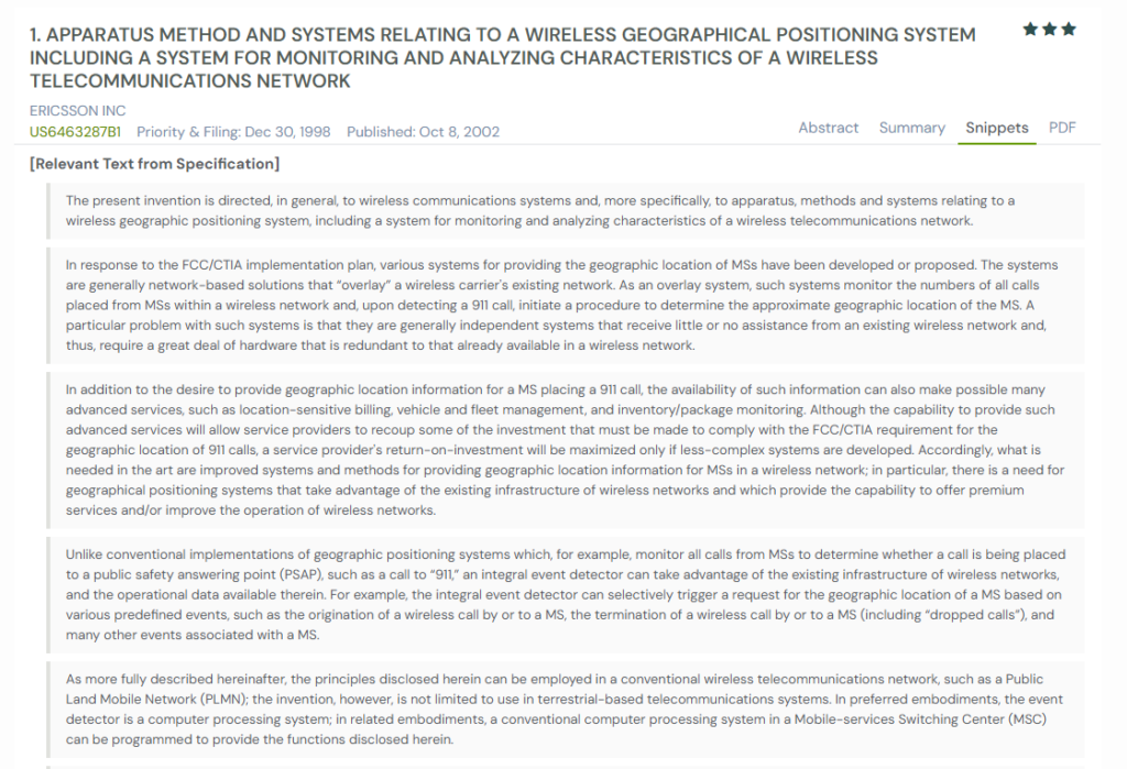
1. US6463287B1
This U.S. patent US6463287B1, published in 2002, introduces systems for wireless geographic positioning that integrate with existing telecommunications infrastructure. Unlike earlier solutions that required costly overlays, this invention leverages existing network components to provide location data more efficiently.
The system responds to the FCC/CTIA requirement for accurate 911 call location, but expands into commercial uses. By monitoring predefined events, such as dropped calls or call initiations, it can trigger location detection dynamically. This enables services like fleet management, package tracking, and location-based billing, while also improving network performance.
Here is a snapshot from our GPS tool depicting the relevant text from specification:
What This Patent Introduces To The Landscape
- Integration of geographic positioning directly into existing wireless network infrastructure
- Event-based triggers for detecting location (e.g., dropped calls, call initiations)
- Logging and analyzing network events to identify coverage or service issues
- Applications beyond emergency calls, including billing, fleet, and inventory management
- Use of graphical displays for monitoring network performance by location
How It Connects To US9549388B2
- Both patents address location tracking within wireless networks for improved services
- US6463287B1 focuses on event-triggered positioning, while US9549388B2 uses traffic and map data for routing
- Each invention reduces reliance on GPS alone by leveraging wireless network intelligence
- Both emphasize expanding mobile services beyond simple connectivity into advanced, location-aware functions
Why This Matters
This patent demonstrates how wireless networks can enhance safety and commercial services through intelligent location tracking. Its event-based monitoring complements the navigation capabilities of US9549388B2, showing how networks can add real-time intelligence to mobile guidance.
Editor’s note: If you’re curious how boundary detection evolved into exclusive mobile advertising zones, check our breakdown of location-based content delivery systems like US8977247B2.
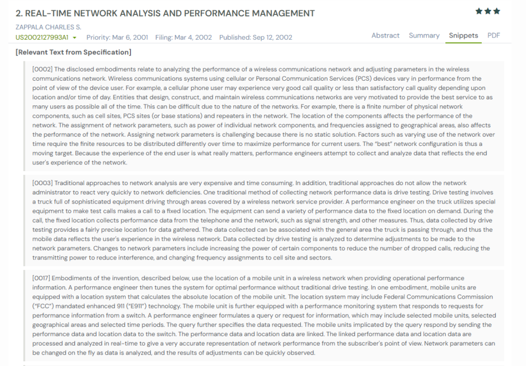
2. US2002127993A1
This U.S. patent US2002127993A1, published in 2002, discloses a system for real-time network analysis and performance management. Instead of relying on traditional, costly methods like drive testing, this invention uses GPS-enabled mobile devices to capture both performance and location data directly from subscribers.
The system continuously collects metrics such as signal strength, bit error rate, and dropped calls. This information is linked with the geographic location of the mobile unit, creating a detailed map of network performance from the user’s perspective. By replacing static testing with live data collection, the system provides a more accurate reflection of actual user experience.
To understand how raw radio measurements feed location and quality analytics, explore US6813742B2 and similar wireless signal-processing patents.
What This Patent Introduces To The Landscape
- Real-time collection of both location and network performance data from mobile devices
- Replacement of drive testing with subscriber-based monitoring methods
- Use of GPS-enabled devices to provide precise positioning for network analysis
- Linked call data and location records for more accurate diagnostics
- Capability to adjust network parameters dynamically and observe results immediately
How It Connects To US9549388B2
- Both patents integrate location awareness with mobile network operations
- US2002127993A1 emphasizes real-time performance management, while US9549388B2 applies location and traffic data to navigation
- Each reduces reliance on static or outdated methods by leveraging live mobile data
- Both support user-focused improvements, ensuring services reflect real conditions
Why This Matters
This patent highlights the shift toward subscriber-driven network intelligence. Its ability to link real-time performance data with precise location complements the adaptive navigation of US9549388B2, showing how mobile devices can enhance both network management and user guidance.
Did you know: The US7231294B2 analysis builds on the same vision of self-guided travel, but for UAVs, where map-based inputs translate directly into flight paths, even without constant connectivity.
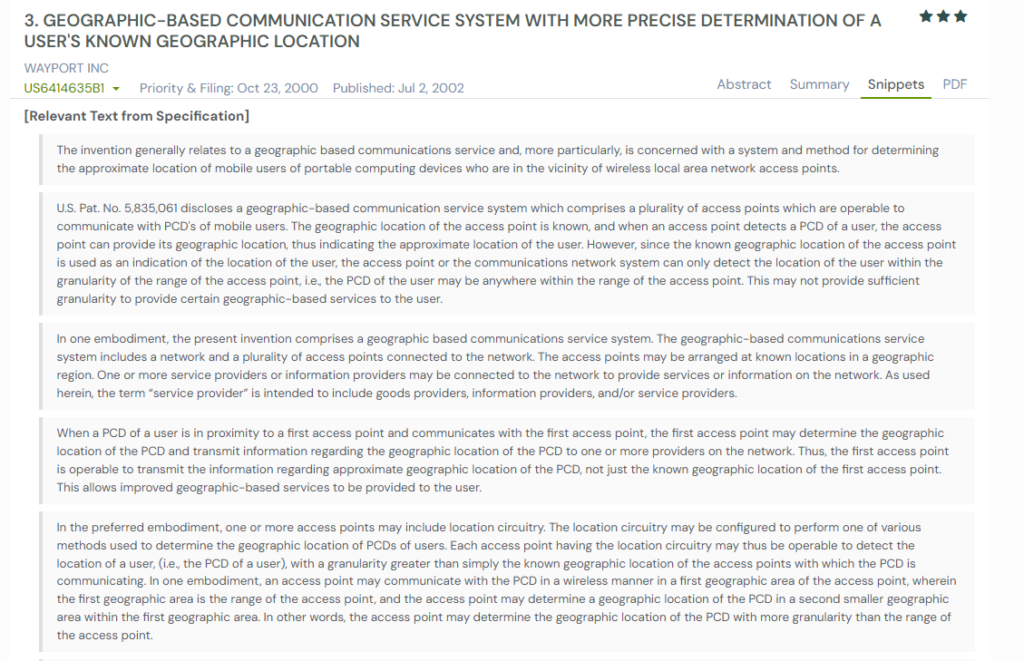
3. US6414635B1
This U.S. patent US6414635B1, published in 2002, introduces a geographic-based communication service system that improves location precision in wireless LANs. This invention equips access points with location circuitry capable of determining a device’s position with much finer granularity.
The system combines several techniques, such as signal strength measurement, triangulation, and time-stamped packets, to estimate a portable computing device’s exact location within a facility. By linking this data with stored maps, the network can provide directions, identify vendor proximity, or even push targeted promotions.
Unlike GPS, which often fails indoors, the approach ensures reliable positioning in places like airports, malls, and hotels. For complementary techniques that help mobile networks discover and refine signals in dense environments, see EP3016464B1 and similar patents that are shaping signal discovery in mobile networks.
What This Patent Introduces To The Landscape
- Access points that estimate device location with fine granularity indoors
- Multiple methods: signal strength, timestamps, triangulation, and bearing
- Map-assisted refinement using known AP coordinates and facility floor plans
- Vendor proximity detection for targeted content and promotions
- Turn-by-turn indoor directions and “Where am I?” responses
- Motion tracking by repeated location fixes across nearby access points
How It Connects To US9549388B2
- Both use network infrastructure to enhance location beyond standalone GPS
- US6414635B1 targets indoor positioning; US9549388B2 targets navigation and routing
- Each leverages maps to contextualize position and deliver guidance
- Both enable location-aware services, though with different network layers
Why This Matters
Indoor precision is critical where GPS falters. This patent shows how WLAN access points can deliver fine-grained location and services, complementing US9549388B2, which optimizes navigation using network intelligence and traffic data.
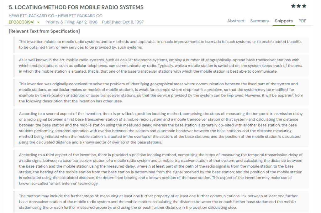
4. EP0800319A1
This European patent EP0800319A1, published in 1997, introduces a locating method for mobile radio systems. It was designed to identify weak coverage areas by measuring signal delays, enabling operators to optimize network layouts. Over time, the method also proved useful for emergency services, fleet management, and tracking.
The invention calculates a mobile station’s distance from base transceiver stations (BTS) using temporal signal delays. It also employs “smart antenna” technology to determine both bearing and distance, producing a more precise location fix. The method supports continuous updates during handovers, which makes it possible to track movement and speed.
What This Patent Introduces To The Landscape
- Position estimation using signal transmission delays between mobile devices and BTS
- Triangulation across multiple BTS for higher accuracy
- Smart antenna integration for bearing and distance determination
- Continuous updates during routine or forced handovers
- Applications for coverage mapping, emergency location, and stolen device tracking
How It Connects To US9549388B2
- Both patents improve mobile services by integrating location awareness into wireless systems
- EP0800319A1 emphasizes network-based signal delay and triangulation; US9549388B2 uses map and traffic data
- Each allows continuous tracking, whether for optimizing networks or guiding navigation
- Both expand traditional wireless communication into location-driven services
Why This Matters
This patent shows how early cellular systems leveraged timing and triangulation for reliable positioning. Its continuous tracking and handover-based updates align with the adaptive goals of US9549388B2, demonstrating the evolution from coverage optimization to full navigation intelligence.
How To Find Similar Patents Using Global Patent Search
Exploring related inventions is essential when studying navigation technologies like US9549388B2. The Global Patent Search (GPS) tool makes it easier to uncover similar systems that use wireless networks, location tracking, or traffic-aware routing. These references reveal how other innovators have approached location services and real-time guidance.

1. Enter the patent number into GPS: Start by typing US9549388B2 into the tool. You can also add terms like “mobile navigation,” “wireless positioning,” or “traffic-aware routing.”
2. Use snippets to learn quickly: GPS provides short text excerpts from related patents, showing how they handle positioning, mapping, or route updates.
3. Look for overlapping functions: Some inventions emphasize precise indoor location, while others refine traffic data or event-based triggers.
4. Compare problem-solving approaches: Certain systems reduce network redundancy, while others focus on enhancing accuracy in low-signal areas.
5. Spot trends in navigation evolution: Reviewing multiple patent filings lets you track shifts from simple GPS-based systems to hybrid solutions that blend maps, network data, and user privacy controls.
Using Global Patent Search helps place any patent in context. By comparing filings and features, you can trace technology trends and spot opportunities across industries.
Disclaimer: The information provided in this article is for informational purposes only and should not be considered legal advice. The related patent references mentioned are preliminary results from the Global Patent Search tool and do not guarantee legal significance. For a comprehensive related patent analysis, we recommend conducting a detailed search using GPS or consulting a patent attorney.