
Did you ever wonder how much precision it takes to fly a drone across unpredictable terrain? Every gust of wind or slight delay in control can throw it off course.
For most operators, steering a UAV is not just about direction. It is a constant effort to balance coordination, timing, and quick adjustments. The farther the drone flies, the harder it becomes to keep it steady and accurate.
That is the problem US7231294B2 set out to solve. Filed by IBM in 2003, it introduced a way to guide drones by simply clicking on a digital map. Each click turned into real-world coordinates, allowing the UAV to calculate its path, adjust for conditions, and reach the destination on its own.
To understand how this innovation shaped the evolution of autonomous flight, we explored it through the Global Patent Search (GPS) tool.
How US7231294B2 Made Drone Navigation Smarter
At its heart, the patent made drone navigation simple, smart, and nearly foolproof. Instead of manually controlling every movement, operators could open a digital map, pick a point with a single click, and let the UAV do the rest.
Behind that click, a lot was happening. The system mapped the exact pixel position on the screen to real-world Global Positioning System coordinates, sent those coordinates to the UAV, and let the onboard navigation computer calculate the best route. It even adjusted for wind, speed, and environmental changes on the way.
Once a mission started, the drone no longer needed constant supervision. Even if the controller lost connection, the UAV could continue flying, reaching each waypoint on its own.
It was a smart balance between human intent and machine autonomy, and it changed how drones were guided forever.
Breaking Down the Core Features of US7231294B2
The strength of the patent lies in how it turned something highly technical into a simple, user-friendly process. Here’s what made it stand out:
- Click-Based Navigation: Operators could select any point on a digital map, and the system instantly converted that location into GPS coordinates for the UAV to follow.
- Autonomous Flight Planning: Once the coordinates were uploaded, the drone calculated its route, adjusted for wind, and navigated independently.
- Multi-Waypoint Missions: Users could set multiple waypoints to design full missions, letting the UAV move from point to point without further input.
- Macro Commands: Each waypoint could trigger specific actions such as capturing images, recording video, or orbiting an area before continuing the route.
- Fail-Safe Intelligence: Even if communication was lost mid-flight, the UAV continued executing its stored mission autonomously.
This mix of automation and reliability made US7231294B2 a foundation for modern drone control systems that now power everything from defense operations to commercial aerial mapping.
Recommended Read – Aerospace innovation, as seen in many top space tech companies, often sets the foundation for UAV advancements. Explore the top 10 space tech companies launching the next autonomy here.
Earlier Patents That Shaped UAV Navigation
Every invention leaves clues about where the next breakthrough will come from. Many nations pursued international patents for UAV guidance systems, reflecting its worldwide importance.
Using the Global Patent Search tool, we traced how earlier ideas around waypoint mapping, digital flight planning, and graphical control evolved over time.
These patents show the gradual shift from manual operation to intelligent, map-based navigation, the foundation on which US7231294B2 was built.
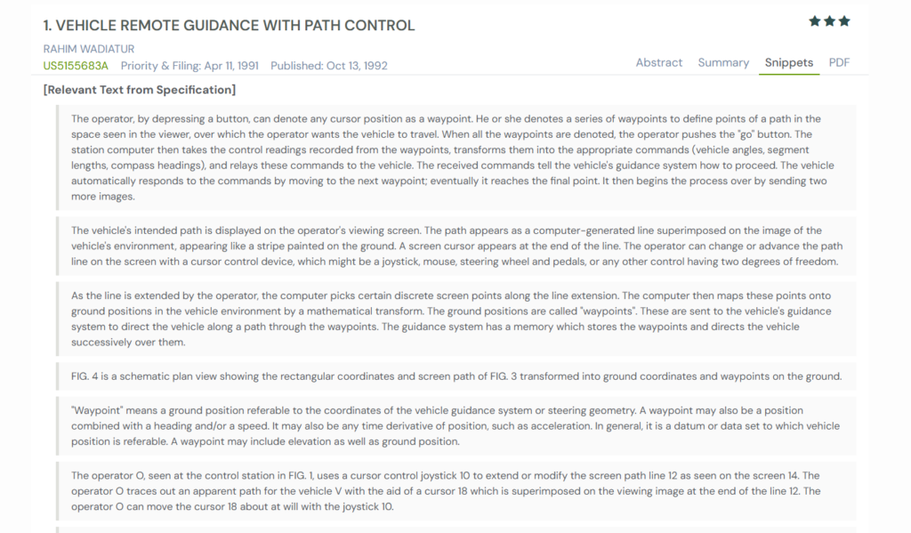
1. US5155683A – Vehicle Remote Guidance with Path Control
Before drones became smart enough to chart their own flight paths, most vehicles either ground or aerial, had to be guided step by step. The operator watched a live video feed and used manual controls to steer, often relying on trial and error to stay on course.
Patent US5155683A, filed in 1991 by Rahim Wadiatur, introduced a clever bridge between human input and machine autonomy. Instead of manually steering, an operator could simply trace a path or click waypoints on a viewing screen. Each selected point was then transformed into real-world ground coordinates, stored in the vehicle’s onboard system, and followed automatically. The vehicle used sensors and internal guidance programs to move from one waypoint to the next, without constant manual intervention.
This idea connects closely with US7231294B2, which expanded the same principle into the air. Where US5155683A turned on-screen paths into ground routes, US7231294B2 used GPS data to let UAVs interpret clicks on a map as flight paths.
The Bigger Picture
US5155683A laid the foundation for visual waypoint navigation that later evolved into true autonomous control.
The concept of translating on-screen points into geographic coordinates directly influenced systems like US7231294B2, where a simple map click could guide a UAV through real GPS-defined routes.
2. US6112141A – Apparatus and Method for Graphically Oriented Aircraft Display and Control
Before autopilot systems became the standard, pilots spent much of their attention juggling maps, coordinates, and cockpit instruments. Even small changes to a route meant re-entering data manually or recalculating flight paths mid-air.
That’s where US6112141A, filed by Dassault Aviation in 1997, introduced a major leap in cockpit automation. The patent described a flight management system that combined digital mapping, waypoint databases, and cursor-based control. Pilots could simply point and click on waypoints displayed on their flight map, and the system would store, modify, or activate flight plans automatically. The interface displayed both horizontal routes and vertical flight profiles, enabling pilots to visualize and adjust their journey in real time with unmatched clarity.
The innovation shares a direct lineage with US7231294B2. Both inventions transformed complex navigation into visual interaction.
While Dassault’s system empowered human pilots to manage manned flights through graphical waypoint control, US7231294B2 extended the same idea to autonomous UAVs, letting them interpret map clicks and self-navigate via GPS with no pilot in the loop.
The Bigger Picture
US6112141A marked the shift from textual command inputs to intuitive graphical control. By letting maps guide machines, it paved the way for modern autonomous navigation, a foundation that US7231294B2 built upon.
A related leap in automation is happening in space tech too. Our Top 10 Space Tech Companies breakdown shows how rockets, satellites, and on-orbit servicing systems now rely on similar autonomous navigation and mission-planning concepts.
3. US6571171B1 – Method and Apparatus for Graphically Inserting Waypoints for a Flight Management System
Pilots often juggle dozens of tasks during flight, from tracking instruments to adjusting routes. Traditional flight systems made this harder by relying on text-based menus for every change. Entering a new waypoint meant typing long coordinates, selecting legs from lists, and losing focus from the sky ahead.
That problem led to US6571171B1, filed by Rockwell Collins in 1999. The patent introduced a visual way to modify flight plans. Pilots could click directly on a map to add or move waypoints.
The system automatically redrew the route using a rubber line that snapped to the nearest flight leg, calculating new paths in real time. It reduced workload and made navigation easier to manage visually.
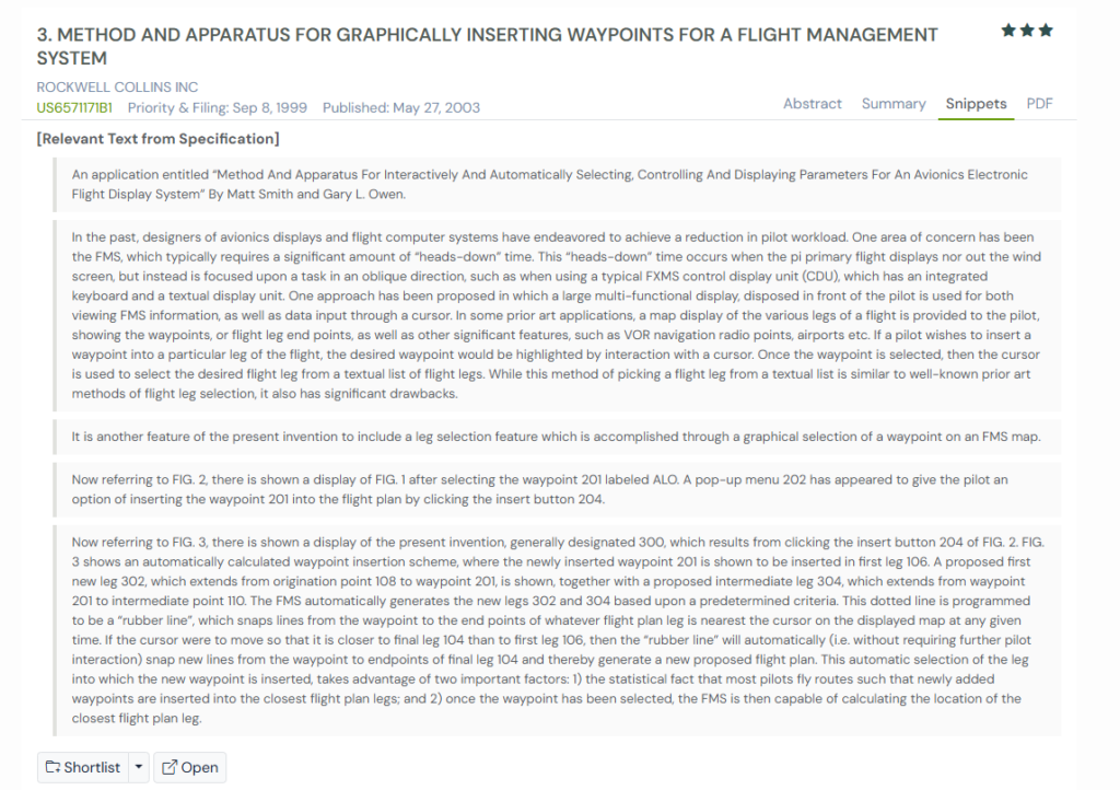
The concept closely overlaps with US7231294B2, which brought the same simplicity to unmanned drones.
The Bigger Picture
US6571171B1 proved that flight management could be visual and intuitive. It bridged the gap between manual inputs and automation, allowing US7231294B2 to push that same idea into fully autonomous UAV navigation.
4. US4642775A – Airborne Flight Planning and Information System
Did you know \before flight computers and digital mapping became common, pilots managed routes using printed charts and manual calculations.
Every flight adjustment, whether a change in route, weather update, or waypoint entry, required careful coordination between air traffic control, onboard instruments, and paper-based flight plans. It was time-consuming and left plenty of room for human error.
That changed with one of the earlier patents, US4642775A, filed by Sundstrand Data Control in 1985. The patent described an early digital flight planning and information system that allowed pilots to build, review, and modify flight plans through a computer display.
They could enter departure points, waypoints, and routes, and the system would calculate distances, fuel consumption, estimated times, and even account for wind conditions. Pilots could store multiple flight plans, review them mid-flight, and make real-time updates using an onboard terminal.
This early digital planning concept set the stage for later innovations like US7231294B2, which applied similar logic to UAVs. Both transformed how flight paths were defined and executed. Sundstrand’s system digitized pilot-guided planning, while US7231294B2 made it fully autonomous through GPS-driven navigation.
The Bigger Picture
US4642775A marked one of the first steps toward computer-based flight planning.
By replacing manual route design with automated calculation and visualization, it laid the groundwork for the kind of intelligent waypoint navigation that US7231294B2 would later bring to autonomous drones.
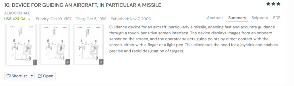
5. US6142410A – Device for Guiding an Aircraft, in Particular a Missile
Controlling fast-moving aircraft or missiles has always been a test of precision. Traditional systems relied on joysticks and manual controls, which demanded intense focus and split-second reflexes from the operator. Making quick target adjustments under pressure was often difficult and left room for error.
Patent US6142410A, filed by Airbus Group in 1998, introduced a more intuitive way to guide aircraft. It replaced mechanical controls with a touch-sensitive screen that displayed live images from onboard sensors. Operators could simply tap on the screen to select a target or waypoint, and the system would instantly compute the new trajectory. This made guidance faster, more accurate, and easier to manage.
The concept connects closely with US7231294B2, which applied similar thinking to UAVs. Both inventions simplified control by turning visual input into automatic navigation commands, driven by precise real-time data.
The Bigger Picture
US6142410A showed how touch-based interfaces could revolutionize aircraft control. By allowing operators to guide through direct interaction instead of hardware, it laid the foundation for technologies like US7231294B2, where UAVs interpret map clicks as GPS-driven flight paths.
A Side-by-Side Look at the Patents That Shaped UAV Navigation
Each of these inventions played a key role in making unmanned flight more intuitive and precise. From early waypoint mapping to touch-based guidance, every step brought drones closer to the seamless click-and-fly experience we know today.
The table below highlights how these ideas evolved and how they connect with US7231294B2.
| Patent No. | Title | Key Focus | Core Mechanism | Connection with US7231294B2 |
| US5155683A | Vehicle Remote Guidance with Path Control | Defining vehicle paths through on-screen waypoints | Converts cursor-selected points into real-world coordinates for autonomous vehicle movement | Introduced the concept of translating screen inputs into ground paths, later adapted for UAV flight in US7231294B2 |
| US6112141A | Apparatus and Method for Graphically Oriented Aircraft Display and Control | Graphical flight management using map-based inputs | Allows pilots to click and modify waypoints directly on digital maps | Served as a visual control model that US7231294B2 evolved into full GPS-driven UAV navigation |
| US6571171B1 | Method and Apparatus for Graphically Inserting Waypoints for a Flight Management System | Simplifying flight plan edits through graphical interfaces | Enables pilots to insert or modify waypoints by clicking on a flight map, automatically recalculating routes | Paved the way for visual-to-autonomous control logic used in US7231294B2 |
| US4642775A | Airborne Flight Planning and Information System | Early digital system for building and reviewing flight plans | Automates waypoint entry, fuel calculation, and route optimization on an onboard computer | Digitized flight planning that US7231294B2 later expanded into autonomous UAV execution |
| US6142410A | Device for Guiding an Aircraft, in Particular a Missile | Touchscreen-based guidance and target selection | Lets operators guide aircraft by tapping on live imagery to assign targets or waypoints | Introduced touch-based precision control that inspired the screen-click navigation logic in US7231294B2 |
Mapping the Bigger Picture with Global Patent Search Tool
Every patent tells part of a larger story, but it is only when you see how they connect that the full picture comes into view. That is where the Global Patent Search tool makes a real difference. It helps trace how one idea sparks another, revealing patterns that link early flight planning systems, waypoint mapping technologies, and modern UAV autonomy.

Here is how GPS helps uncover those connections:
- Begin from any patent: Enter a number such as US7231294B2 or describe it briefly, and GPS will instantly surface related patents on UAV navigation, guidance systems, or flight automation.
- Find the hidden links: It shows short, meaningful snippets that reveal how different inventors solved similar technical challenges.
- Go beyond the surface: You can open detailed documents to understand how earlier designs inspired new capabilities or adaptations.
- Discover cross-industry patterns: GPS highlights how navigation ideas in aerospace, defense, and robotics often overlap and evolve together.
By bringing all these insights into one place, the GPS tool helps innovators and researchers trace how technology grows, connects, and shapes the next generation of breakthroughs.
If you are curious to see how one breakthrough leads to another, the GPS tool is the perfect place to start your exploration. Try the tool today!
Disclaimer: The information provided in this article is for informational purposes only and should not be considered legal advice. The related patent references mentioned are preliminary results from the Global Patent Search tool and do not guarantee legal significance. For a comprehensive related patent analysis, we recommend conducting a detailed search using GPS or consulting a patent attorney.
Frequently Asked Questions
1. What role do machine learning and AI play in modern UAV navigation patents?
Recent patents describe AI-based navigation models that allow drones to recognize obstacles, adapt to weather, or optimize routes in real time. These systems rely on deep learning for object detection and reinforcement learning for flight path optimization.
2. What are the environmental benefits of modern UAV navigation systems?
Efficient navigation reduces energy consumption by minimizing idle time and optimizing flight routes. In sectors like agriculture and environmental monitoring, UAVs enable precise surveying with minimal carbon footprint compared to manned aircraft.
3. Which industries benefit most from UAV navigation innovations?
Besides aerospace, industries like logistics, construction, agriculture, and defense benefit significantly. For instance, precision farming uses UAVs for mapping soil health, while delivery firms use them for automated last-mile logistics.